ST2-Forest
Strengthen Forest Landscape Management and Restoration for Watershed Services
and Biodiversity Conservation to Response to Future Land Use and Climate
Change
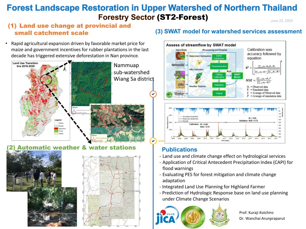
- To install Automatic Weather Station (AWS) at 5 sites in Upper Nan Watershed for sustainable rainfall data collection
- To create land use scenarios, future land-use/land-cover maps, predicted deforestation maps, ecosystem service maps (water yield, biodiversity, sediment)
- To simulate cost/benefit in various adaptation measures
Members
Thai Side
- Wanchai ARUNPRAPARUT – Kasetsart University (KU)
- Venus TUANKRUA – Kasetsart University (KU)
- Yongyut TRISURAT – Kasetsart University (KU)
- Nipon TUNGTHAM – Kasetsart University (KU)
- Pintip THITIROJANAWAT – Department of National Parks, Wildlife and Plant Conservation (DNP)
- Krongkaew SRIPRARAM – Department of National Parks, Wildlife and Plant Conservation (DNP)
- Kanyarat NETBUT – Department of National Parks, Wildlife and Plant Conservation (DNP)
- Anupong GABJUN – Department of National Parks, Wildlife and Plant Conservation (DNP)
- Chatchai YOTHAWUT – Department of National Parks, Wildlife and Plant Conservation (DNP)
- Wipaporn BAIYA – Department of National Parks, Wildlife and Plant Conservation (DNP)
- Jaray KHANTEE – Department of National Parks, Wildlife and Plant Conservation (DNP)
- Warisa LUMBAN – Department of National Parks, Wildlife and Plant Conservation (DNP)
- Suchat KALAYAWONGSA – Royal Forest Department (RFD)
- Somkid SAPAOKUM – Royal Irrigation Department (RID)
- Nilobol ARANYABHAGA – Office of National Water Resources (ONWR)
Japanese Side
- Koichiro KURAJI – The University of Tokyo (UT)
- Masashi KIGUCHI – The University of Tokyo (UT)
Objective:
- To study land use scenarios of Nan province
- To evaluate ecosystem services from land use scenarios
- To find out the suitable sizes and places of forest to maximize ecosystem services
Expected Outcomes
- Predicted land-use change maps based on different demand scenarios
- Quantified watershed services and functions (e.g., water yield, sediment and nutrient retention) and maps under climate change scenarios
- Priority areas for landscape restoration in accordance to payment for ecosystem services (PES) and optimum investment
- Adaptation approach of people in watershed (e.g., agricultural practices, crop varieties,, growing season, settlement location)
Description of Activities
- Installation of AWS and maintenance
- Installation of weir for SWAT model calibration
- Collection of soil samples
- Test of CLUE-s model
Progress in June 2020


